


Subsurface particle transport shapes the deep critical zone in a granitoid watershed
Affiliations | Corresponding Author | Cite as | Funding information
Published by the European Association of Geochemistry
under Creative Commons License CC BY 4.0
Keywords: weathering, subsurface particle transport, fracture, granitoid


- Share this article


-
Article views:125Cumulative count of HTML views and PDF downloads.
- Download Citation
- Rights & Permissions

top
Abstract
Figures
 Figure 1 (a) Study locations at Río Icacos watershed in Puerto Rico. Colours indicate elevation, which are from USGS 3D Elevation Program through Open Topography. (b) Sampling location of seep sediments. Aerial imagery is from Esri (2017). (c) Na/Al and Ca/Al molar ratios of different solid end members (corestone, rindlet, seep sediment, stream sediment and saprolite/soil) determined through bulk analysis. Most Na and Ca are present in plagioclase in the bedrock, so as plagioclase weathers, the Na/Al and Ca/Al molar ratios decrease (Al is assumed to be not solubilised during plagioclase weathering). | 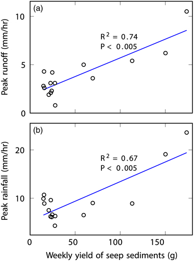 Figure 2 (a) Hourly peak runoff and (b) maximum rainfall intensity during the sampling week versus weekly accumulated mass of seep sediments. P = p value. |  Figure 3 (a, b) Elemental maps and (c–f) backscattered electron images of the edge of rindlets (a–d) and seep sediments (e, f). The rindlet sample is from borehole LGW1 at 5.38–5.40 metres below land surface (LGW1 1-20) and the seep sediments were collected during August 9–16, 2016 (0.85–2.56 mm size fraction). Ap: apatite, Bt: biotite, Chl: chlorite, Hbl: hornblende, Kln: kaolinite, K-spar: K-feldspar, Pl: plagioclase, Qz: quartz, Vrm: vermiculite. | 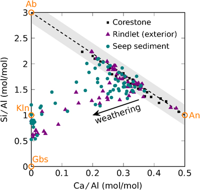 Figure 4 Si/Al and Ca/Al molar ratios determined by scanning electron microscopy energy dispersive X-ray spectroscopy (EDS) on individual plagioclase grains from different solid end members (corestone, rindlet and seep sediment). The orange circles represent sodium-rich (albite, Ab) and calcium-rich (anorthite, An) plagioclase and typical weathering products of plagioclase such as gibbsite (Gbs) and kaolinite (Kln). The dashed line represents solid solution mixing of Ab and An. Shaded zone shows one standard deviation of uncertainty in Ca/Al molar ratios assuming the relative error of EDS measurement is 5 %. Therefore, the points within the shaded zone are considered as unaltered plagioclase. |
| Figure 1 | Figure 2 | Figure 3 | Figure 4 |
top
Introduction
In watershed studies, identification of the input and output components of a mass balance model is the first and the most critical step to quantify fluxes and their importance in the evolution of the critical zone—the layer from the canopy of the trees to the groundwater (Chadwick et al., 1990
Chadwick, O.A., Brimhall, G.H., Hendricks, D.M. (1990) From a black to a gray box – a mass balance interpretation of pedogenesis. Geomorphology 3, 369–390.
; Riebe et al., 2017Riebe, C.S., Hahm, W.J., Brantley, S.L. (2017) Controls on deep critical zone architecture: a historical review and four testable hypotheses. Earth Surface Processes and Landforms 42, 128–156.
). However, many models are based on incorrect a priori assumptions, and end up neglecting important fluxes. For example, most denudation studies are based on the assumption that subsurface losses occur only through the chemical mobilisation of solutes with physical erosion only important for the mobile soil layer (see Riebe et al., 2017Riebe, C.S., Hahm, W.J., Brantley, S.L. (2017) Controls on deep critical zone architecture: a historical review and four testable hypotheses. Earth Surface Processes and Landforms 42, 128–156.
and references therein). However, soil and sediment particles also move below the land surface and even below the soil layer. Subsurface particle transport has been discussed by geomorphologists (e.g., Dunne, 1990Dunne, T. (1990) Hydrology mechanics, and geomorphic implications of erosion by subsurface flow. In: Higgins, C.G., Coates, D.R. (Eds.) Groundwater geomorphology: The role of subsurface water in Earth-surface processes and landforms. Geological Society of America, Boulder, 1–28.
), but weathering implications have only been highlighted in a few locations (e.g., Bern et al., 2015Bern, C.R., Thompson, A., Chadwick, O.A. (2015) Quantification of colloidal and aqueous element transfer in soils: The dual-phase mass balance model. Geochimica et Cosmochimica Acta 151, 1–18.
; Kim et al., 2018Kim, H., Gu, X., Brantley, S.L. (2018) Particle fluxes in groundwater change subsurface shale rock chemistry over geologic time. Earth and Planetary Science Letters 500, 180–191.
).To explore the significance of subsurface particle transport in the Luquillo Mountains, Puerto Rico at a site where such transport has been noted (Harrison et al., 2020
Harrison, E.J., Brocard, G.Y., Gasparini, N.M., Lyons, N.J., Willenbring, J.K. (2020) Seepage erosion in the Luquillo Mountains, Puerto Rico, relict landscapes. Journal of Geophysical Research: Earth Surface 125, e2019JF005341.
), we examined “seep sediments” collected from a seep along a steep slope and stream sediments from stream beds in the Río Icacos watershed. As one of the fastest weathering and eroding granitoid systems in the world (White and Blum, 1995White, A.F., Blum, A.E. (1995) Effects of climate on chemical weathering in watersheds. Geochimica et Cosmochimica Acta 59, 1729–1747.
), this site has been well studied (White et al., 1998White, A.F., Blum, A.E., Schulz, M.S., Vivit, D.V., Stonestrom, D.A., Larsen, M., Murphy, S.F., Eberl, D. (1998) Chemical weathering in a tropical watershed, Luquillo mountains, Puerto Rico: I. Long-term versus short-term weathering fluxes. Geochimica et Cosmochimica Acta 62, 209–226.
; Buss et al., 2008Buss, H.L., Sak, P.B., Webb, S.M., Brantley, S.L. (2008) Weathering of the Rio Blanco quartz diorite, Luquillo Mountains, Puerto Rico: Coupling oxidation, dissolution, and fracturing. Geochimica et Cosmochimica Acta 72, 4488–4507.
; Shanley et al., 2011Shanley, J.B., McDowell, W.H., Stallard, R.F. (2011) Long-term patterns and short-term dynamics of stream solutes and suspended sediment in a rapidly weathering tropical watersheds. Water Resources Research 47, W07515.
; Comas et al., 2019Comas, X., Wright, W., Hynek, S.A., Fletcher, R.C., Brantley, S.L. (2019) Understanding fracture distribution and its relation to knickpoint evolution in the Rio Icacos watershed (Luquillo Critical Zone Observatory, Puerto Rico) using landscape-scale hydrogeophysics. Earth Surface Processes and Landforms 44, 877–885.
), allowing us to elucidate how subsurface particle transport contributes to shaping the deep critical zone.top
Weathering in the Río Icacos Watershed
The Río Icacos is a bowl-shaped 3.26 km2 watershed located in the headwaters of the Río Blanco in the Luquillo Mountains of northeastern Puerto Rico (Fig. 1a). This humid, montane tropical forested watershed is almost exclusively developed on the Río Blanco Quartz Diorite, a pluton that contains predominantly plagioclase and quartz (White et al., 1998
White, A.F., Blum, A.E., Schulz, M.S., Vivit, D.V., Stonestrom, D.A., Larsen, M., Murphy, S.F., Eberl, D. (1998) Chemical weathering in a tropical watershed, Luquillo mountains, Puerto Rico: I. Long-term versus short-term weathering fluxes. Geochimica et Cosmochimica Acta 62, 209–226.
). In Río Icacos, it has been well documented that spheroidal weathering, initiated by biotite oxidation and volume expansion, fractures to form cm-sized, onion-like rindlets that wrap around increasingly spheroidal corestones (Buss et al., 2008Buss, H.L., Sak, P.B., Webb, S.M., Brantley, S.L. (2008) Weathering of the Rio Blanco quartz diorite, Luquillo Mountains, Puerto Rico: Coupling oxidation, dissolution, and fracturing. Geochimica et Cosmochimica Acta 72, 4488–4507.
). Each rindlet is characterised by fine micro-cracks and is separated from other rindlets by larger macro-cracks. The zone of rindlets (∼0.5–1 m in thickness) transforms to the thick layer of overlying saprolite and soil. In the following, we first discuss the potential importance of seep sediments and then present evidence for the mechanism of their formation.Figure 1 (a) Study locations at Río Icacos watershed in Puerto Rico. Colours indicate elevation, which are from USGS 3D Elevation Program through Open Topography. (b) Sampling location of seep sediments. Aerial imagery is from Esri (2017)
Esri (2017) “World Imagery” [imagery]. 1:6,700 scale. “World Imagery”. October 24, 2017. https://www.arcgis.com/home/item.html?id=10df2279f9684e4a9f6a7f08febac2a9. (September 16, 2021).
. (c) Na/Al and Ca/Al molar ratios of different solid end members (corestone, rindlet, seep sediment, stream sediment and saprolite/soil) determined through bulk analysis. Most Na and Ca are present in plagioclase in the bedrock, so as plagioclase weathers, the Na/Al and Ca/Al molar ratios decrease (Al is assumed to be not solubilised during plagioclase weathering).top
Characteristics of Seep and Stream Sediments
Seep sediments were sampled from a perennial seep emanating from between corestones in a roadcut wall along Route 191 (Fig. 1b), situated on a steep slope from mountain top to river bottom. The weekly yield of seep sediments produced at the seep during the sampling periods (August–November, 2016) varied by more than one order of magnitude and showed positive correlations with peak discharge and peak rainfall (Fig. 2). The particle size distribution of seep sediments, which varies with discharge (Fig. S-1), is dominated by particles in the upper sand size range (median size: 0.4–1.6 mm). Dissolved Si concentrations in water sampled at the seep during the study measured 375 ± 35 μM, consistent with groundwater that has circulated to tens of metres depth (cf. Shanley et al., 2011
Shanley, J.B., McDowell, W.H., Stallard, R.F. (2011) Long-term patterns and short-term dynamics of stream solutes and suspended sediment in a rapidly weathering tropical watersheds. Water Resources Research 47, W07515.
; Hynek et al., 2017Hynek, S., Comas, X., Brantley, S.L. (2017) The effect of fractures on weathering of igneous and volcaniclastic sedimentary rocks in the Puerto Rican tropical rain forest. 15th Water-rock Interaction International Symposium, Wri-15. 972–975.
).Figure 2 (a) Hourly peak runoff and (b) maximum rainfall intensity during the sampling week versus weekly accumulated mass of seep sediments. P = p value.
Twelve stream sediment samples were collected from beds of the Río Icacos and Quebrada Guaba (an Icacos tributary draining Guaba Ridge, Fig. 1a). The geochemical, mineralogical, and textural signatures indicate the stream sediments are likely mixtures of seep sediments + soils/saprolites. As shown by Buss et al. (2008)
Buss, H.L., Sak, P.B., Webb, S.M., Brantley, S.L. (2008) Weathering of the Rio Blanco quartz diorite, Luquillo Mountains, Puerto Rico: Coupling oxidation, dissolution, and fracturing. Geochimica et Cosmochimica Acta 72, 4488–4507.
, the composition of the quartz diorite changes as it is transformed first into rindlets, then saprolite, and ultimately soil. Specifically, the extent of depletion in Ca and Na (increasing depletion of plagioclase) increases roughly from corestone to rindlet to seep sediment to stream sediment to soil/saprolite (Fig. 1c). The X-ray diffraction (XRD) patterns and the grain size distributions show the same trends, consistent with weathering extent in these materials (Supplementary Information). Similarly, the concentrations of cosmogenic 10Be in stream sediments at Río Icacos are lower as compared to the soils (Brown et al., 1995Brown, E.T., Stallard, R.F., Larsen, M.C., Raisbeck, G.M., Yiou, F. (1995) Denudation rates determined from the accumulation of in situ-produced 10Be in the Luquillo Experimental Forest, Puerto Rico. Earth and Planetary Science Letters 129, 193–202.
; Brocard et al., 2015Brocard, G.Y., Willenbring, J.K., Scatena, F.N., Johnson, A.H. (2015) Effects of a tectonically-triggered wave of incision on riverine exports and soil mineralogy in the Luquillo Mountains of Puerto Rico. Applied Geochemistry 63, 586–598.
). These results are consistent with stream sediments in the Río Icacos deriving not only from soils, but also from less weathered materials. These materials were previously assumed to have been delivered by landslides scouring material from depth (Brown et al., 1995Brown, E.T., Stallard, R.F., Larsen, M.C., Raisbeck, G.M., Yiou, F. (1995) Denudation rates determined from the accumulation of in situ-produced 10Be in the Luquillo Experimental Forest, Puerto Rico. Earth and Planetary Science Letters 129, 193–202.
; Dosseto et al., 2014Dosseto, A., Buss, H.L., Chabaux, F. (2014) Age and weathering rate of sediments in small catchments: The role of hillslope erosion. Geochimica et Cosmochimica Acta 132, 238–258.
). Here, we propose an alternative or additional pathway that these materials are transported as particles through the subsurface.The characteristics of the seep sediments allow us to constrain the sources of stream sediments at Río Icacos. Assuming that 1) stream sediments are composed of soil/saprolite plus a less weathered component, 2) Al is not solubilised during chemical weathering, and 3) the less weathered component is chemically similar to seep sediments, we estimated 46 ± 22 % and 88 ± 10 % of Na and Ca in the stream sediments at the gages of Río Icacos and Quebrada Guaba (Fig. 1a), respectively, are sourced from seep sediments or similar less weathered materials (Supplementary Information).
top
How Subsurface Particle Transport Occurs at Río Icacos
We now consider how such seep sediments might form. In rocks, chemical processes can reduce rock cohesion and enhance the hydraulic conductivity and allow subsurface erosion to occur (Dunne, 1990
Dunne, T. (1990) Hydrology mechanics, and geomorphic implications of erosion by subsurface flow. In: Higgins, C.G., Coates, D.R. (Eds.) Groundwater geomorphology: The role of subsurface water in Earth-surface processes and landforms. Geological Society of America, Boulder, 1–28.
; Lamb et al., 2006Lamb, M.P., Howard, A.D., Johnson, J., Whipple, K.X., Dietrich, W.E., Perron, J.T. (2006) Can springs cut canyons into rock? Journal of Geophysical Research: Planets 111, E07002.
). In the following sections, we summarise observations that document these requirements for subsurface particle transport at Río Icacos: 1) fracture surfaces show enhanced chemical weathering, and 2) the fractured network can support sufficient flow velocities, driven by high hydraulic gradients, to entrain particles.At Río Icacos, the oxidation of biotite is hypothesised to fracture rock at depth and create fracture-delineated rindlets around the outermost parts of each corestone (e.g., spheroidal weathering; Fletcher et al., 2006
Fletcher, R.C., Buss, H.L., Brantley, S.L. (2006) A spheroidal weathering model coupling porewater chemistry to soil thicknesses during steady-state denudation. Earth and Planetary Science Letters 244, 444–457.
; Buss et al., 2008Buss, H.L., Sak, P.B., Webb, S.M., Brantley, S.L. (2008) Weathering of the Rio Blanco quartz diorite, Luquillo Mountains, Puerto Rico: Coupling oxidation, dissolution, and fracturing. Geochimica et Cosmochimica Acta 72, 4488–4507.
). The textures and compositions of the rindlet interiors are similar to that of the corestones because weathering roughly occurs from outside to inside (Fig. S-2). For example, the degree of alteration of the plagioclase and biotite increases dramatically toward the fracture surface (Fig. 3a–d). Alteration consists of fracturing of the plagioclase as calcic cores become increasingly dissolved or replaced by kaolinite (Fig. 3c). Biotite grains, which become partially to fully altered to vermiculite, increasingly exfoliate parallel to the cleavage plane at the rindlet edges (Fig. 3d). Also, the dissolution of plagioclase (Fig. 3a,c) and exfoliation of biotite (Fig. 3b,d) make these grains easy to detach physically.Figure 3 (a, b) Elemental maps and (c–f) backscattered electron images of the edge of rindlets (a–d) and seep sediments (e, f). The rindlet sample is from borehole LGW1 at 5.38–5.40 metres below land surface (LGW1 1-20) and the seep sediments were collected during August 9–16, 2016 (0.85–2.56 mm size fraction). Ap: apatite, Bt: biotite, Chl: chlorite, Hbl: hornblende, Kln: kaolinite, K-spar: K-feldspar, Pl: plagioclase, Qz: quartz, Vrm: vermiculite.
Figure 4 exemplifies some of these characteristics. Elemental compositions of plagioclase grains in corestones plot on the mixing line of sodium-rich and calcium-rich plagioclase, showing no chemical weathering (Fig. 4). In contrast, the chemical compositions of plagioclase grains located at the exterior of rindlets span a wide range from unaltered plagioclase to kaolinite and gibbsite, and more than half of the grains are altered. These altered compositions approach that of seep sediments (Fig. 4). We infer that the seep sediments likely originated from the fracture surfaces.
Figure 4 Si/Al and Ca/Al molar ratios determined by scanning electron microscopy energy dispersive X-ray spectroscopy (EDS) on individual plagioclase grains from different solid end members (corestone, rindlet and seep sediment). The orange circles represent sodium-rich (albite, Ab) and calcium-rich (anorthite, An) plagioclase and typical weathering products of plagioclase such as gibbsite (Gbs) and kaolinite (Kln). The dashed line represents solid solution mixing of Ab and An. Shaded zone shows one standard deviation of uncertainty in Ca/Al molar ratios assuming the relative error of EDS measurement is 5 %. Therefore, the points within the shaded zone are considered as unaltered plagioclase.
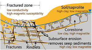
Some of these observations may explain previous geophysical observations at Río Icacos. Ground penetrating radar (GPR) surveys indicated that eroding channels in the hillside leading to the river are usually co-located with vertical zones of enhanced GPR reflection. These were interpreted as deep fracture zones filled with rindletted corestones (Comas et al., 2019
Comas, X., Wright, W., Hynek, S.A., Fletcher, R.C., Brantley, S.L. (2019) Understanding fracture distribution and its relation to knickpoint evolution in the Rio Icacos watershed (Luquillo Critical Zone Observatory, Puerto Rico) using landscape-scale hydrogeophysics. Earth Surface Processes and Landforms 44, 877–885.
). Field measurements across these fracture zones showed coincident decreases in terrain conductivity and increases in magnetic susceptibility (Comas et al., 2019Comas, X., Wright, W., Hynek, S.A., Fletcher, R.C., Brantley, S.L. (2019) Understanding fracture distribution and its relation to knickpoint evolution in the Rio Icacos watershed (Luquillo Critical Zone Observatory, Puerto Rico) using landscape-scale hydrogeophysics. Earth Surface Processes and Landforms 44, 877–885.
). To test what might cause this, we conducted magnetic susceptibility (MS) measurements in the laboratory and observed that the MS values decreased from corestones ≈ rindlets > seep sediments > soils (Table S-1). The decrease of MS is likely due to depletion of magnetite during weathering as documented by XRD (Supplementary Information); these measurements also showed that clay minerals (known to generally show relatively high electrical conductivity, EC (Palacky, 1987Palacky, G.J. (1987) Resistivity characteristics of geologic targets. In: Nabighian, M.N. (Ed.) Electromagnetic Methods in Applied Geophysics. Society of Exploration Geophysicists, Tulsa, 52–129.
)) are enriched in seep sediments (Table S-2). These new data therefore show that the low EC in fracture zones could be caused by loss of particles like the clay-rich seep sediments while the high MS could be caused by retention of magnetite in the corestones and rindlets as seep sediment-like particles are removed.Another geomorphological characteristic, amphitheatre-shaped headwalls throughout the Río Icacos, provides additional evidence of seepage erosion (Harrison et al., 2020
Harrison, E.J., Brocard, G.Y., Gasparini, N.M., Lyons, N.J., Willenbring, J.K. (2020) Seepage erosion in the Luquillo Mountains, Puerto Rico, relict landscapes. Journal of Geophysical Research: Earth Surface 125, e2019JF005341.
). For example, the steep slopes of headwalls around the sampled seep (27–60°) should provide a sufficient hydraulic gradient for subsurface particle flow. Hydrologic calculations also suggest that the size of fracture apertures is large enough to accommodate the size of seep sediments (Supplementary Information). In fact, during drilling in the quartz diorite, movement of particles in the subsurface between boreholes separated by 1 m has even been noted (Orlando, 2014Orlando, J. (2014) The anatomy of weathering profiles on different lithologies in the tropical forest of northeastern Puerto Rico: from bedrock to clouds. Master thesis: Pennsylvania State University.
).top
Fracture Surfaces are Hot Spots for Weathering and Erosion
The chemical weathering rate of silicates as indicated by the riverine flux at Río Icacos is among the highest reported for granitoid watersheds (White and Blum, 1995
White, A.F., Blum, A.E. (1995) Effects of climate on chemical weathering in watersheds. Geochimica et Cosmochimica Acta 59, 1729–1747.
). However, the high weathering rate at Río Icacos cannot be fully explained by the humid tropical climate since the rate is 4 to 20 times higher than other granitoid watersheds in tropical areas with high precipitation (Edmond et al., 1995Edmond, J.M., Palmer, M.R., Measures, C.I., Grant, B., Stallard, R.F. (1995) The fluvial geochemistry and denudation rate of the Guayana Shield in Venezuela, Colombia, and Brazil. Geochimica et Cosmochimica Acta 59, 3301–3325.
; von Blanckenburg et al., 2004von Blanckenburg, F., Hewawasam, T., Kubik, P.W. (2004) Cosmogenic nuclide evidence for low weathering and denudation in the wet, tropical highlands of Sri Lanka. Journal of Geophysical Research: Earth Surface 109, F03008.
; Braun et al., 2012Braun, J.-J., Marechal, J.-C., Riotte, J., Boeglin, J.-L., Bedimo Bedimo, J.-P., Ndam Ngoupayou, J.R., Nyeck, B., Robain, H., Sekhar, M., Audry, S., Viers, J. (2012) Elemental weathering fluxes and saprolite production rate in a Central African lateritic terrain (Nsimi, South Cameroon). Geochimica et Cosmochimica Acta 99, 243–270.
). The high weathering flux at Río Icacos has previously been attributed to the interconnected fractures that allow fast infiltration of oxygenated meteoric water that can accelerate weathering at multiple depths (e.g., Fletcher et al., 2006Fletcher, R.C., Buss, H.L., Brantley, S.L. (2006) A spheroidal weathering model coupling porewater chemistry to soil thicknesses during steady-state denudation. Earth and Planetary Science Letters 244, 444–457.
). Our study suggests that the transport of sand-sized particles through fractures at Río Icacos is an under-appreciated mechanism that exposes fresh particle surfaces to weathering fluids. Subsurface particle transport has not been previously invoked to explain the 10 fold discrepancies between short term denudation rates inferred from solid loads at stream gages (Stallard, 2012Stallard, R.F. (2012) Weathering, landscape equilibrium, and carbon in four watersheds in eastern Puerto Rico. USGS Professional Paper 1789-H.
) and the long term denudation rates inferred from cosmogenic 10Be (Brown et al., 1995Brown, E.T., Stallard, R.F., Larsen, M.C., Raisbeck, G.M., Yiou, F. (1995) Denudation rates determined from the accumulation of in situ-produced 10Be in the Luquillo Experimental Forest, Puerto Rico. Earth and Planetary Science Letters 129, 193–202.
). The stream sediments of Río Icacos are enriched in cosmogenic 10Be from soils, but also contain seep sediments that do not contain 10Be due to delivery from depth. Whether this means that denudation rates are underestimated remains to be explored.Chemical weathering in fractured rocks has been relatively well studied. However, our understanding of particle transport through fractures is very limited because it is based on only a few studies such as those in carbonate (Levenson and Emmanuel, 2017
Levenson, Y., Emmanuel, S. (2017) Repulsion between calcite crystals and grain detachment during water-rock interaction. Geochemical Perspectives Letters 3, 133–141.
) or carbonate-rich shale lithologies (Deng et al., 2017Deng, H., Voltolini, M., Molins, S., Steefel, C., DePaolo, D., Ajo-Franklin, J., Yang, L. (2017) Alteration and erosion of rock matrix bordering a carbonate-rich shale fracture. Environmental Science & Technology 51, 8861–8868.
). The significance of subsurface particle transport depends on disaggregation related to weathering of the fracture surface, the size of the particles relative to the fracture apertures, the fracture connectivity, and the hydraulic gradient. Subsurface particle transport is an under-appreciated process that likely shapes the deep critical zone and promotes chemical and physical weathering in mountainous areas with well developed fracture networks like the Luquillo Mountains. More investigations are needed to characterise particle transport by subsurface flow through different fracture geometries, in different lithologies, and at different temporal and spatial scales.top
Acknowledgements
We thank technical support from the Materials Characterization Laboratory and Laboratory for Isotopes and Metals in the Environment at the Pennsylvania State University. We thank Jean-Marc Baele and an anonymous reviewer for helpful comments. This work was funded by the National Science Foundation Luquillo Critical Zone Observatory (NSF-LCZO), Grant EAR 1331841 to Bill McDowell.
Editor: Sophie Opfergelt
top
References
Bern, C.R., Thompson, A., Chadwick, O.A. (2015) Quantification of colloidal and aqueous element transfer in soils: The dual-phase mass balance model. Geochimica et Cosmochimica Acta 151, 1–18.
 Show in context
 Subsurface particle transport has been discussed by geomorphologists (e.g., Dunne, 1990), but weathering implications have only been highlighted in a few locations (e.g., Bern et al., 2015; Kim et al., 2018).
View in article
Braun, J.-J., Marechal, J.-C., Riotte, J., Boeglin, J.-L., Bedimo Bedimo, J.-P., Ndam Ngoupayou, J.R., Nyeck, B., Robain, H., Sekhar, M., Audry, S., Viers, J. (2012) Elemental weathering fluxes and saprolite production rate in a Central African lateritic terrain (Nsimi, South Cameroon). Geochimica et Cosmochimica Acta 99, 243–270.
Show in context However, the high weathering rate at Río Icacos cannot be fully explained by the humid tropical climate since the rate is 4 to 20 times higher than other granitoid watersheds in tropical areas with high precipitation (Edmond et al., 1995; von Blanckenburg et al., 2004; Braun et al., 2012).
View in article
Brocard, G.Y., Willenbring, J.K., Scatena, F.N., Johnson, A.H. (2015) Effects of a tectonically-triggered wave of incision on riverine exports and soil mineralogy in the Luquillo Mountains of Puerto Rico. Applied Geochemistry 63, 586–598.
Show in context Similarly, the concentrations of cosmogenic 10Be in stream sediments at Río Icacos are lower as compared to the soils (Brown et al., 1995; Brocard et al., 2015).
View in article
Brown, E.T., Stallard, R.F., Larsen, M.C., Raisbeck, G.M., Yiou, F. (1995) Denudation rates determined from the accumulation of in situ-produced 10Be in the Luquillo Experimental Forest, Puerto Rico. Earth and Planetary Science Letters 129, 193–202.
Show in context Similarly, the concentrations of cosmogenic 10Be in stream sediments at Río Icacos are lower as compared to the soils (Brown et al., 1995; Brocard et al., 2015).
View in article
These materials were previously assumed to have been delivered by landslides scouring material from depth (Brown et al., 1995; Dosseto et al., 2014).
View in article
Subsurface particle transport has not been previously invoked to explain the 10 fold discrepancies between short term denudation rates inferred from solid loads at stream gages (Stallard, 2012) and the long term denudation rates inferred from cosmogenic 10Be (Brown et al., 1995).
View in article
Buss, H.L., Sak, P.B., Webb, S.M., Brantley, S.L. (2008) Weathering of the Rio Blanco quartz diorite, Luquillo Mountains, Puerto Rico: Coupling oxidation, dissolution, and fracturing. Geochimica et Cosmochimica Acta 72, 4488–4507.
Show in context In Río Icacos, it has been well documented that spheroidal weathering, initiated by biotite oxidation and volume expansion, fractures to form cm-sized, onion-like rindlets that wrap around increasingly spheroidal corestones (Buss et al., 2008).
View in article
As shown by Buss et al. (2008), the composition of the quartz diorite changes as it is transformed first into rindlets, then saprolite, and ultimately soil.
View in article
At Río Icacos, the oxidation of biotite is hypothesised to fracture rock at depth and create fracture-delineated rindlets around the outermost parts of each corestone (e.g., spheroidal weathering; Fletcher et al., 2006; Buss et al., 2008).
View in article
As one of the fastest weathering and eroding granitoid systems in the world (White and Blum, 1995), this site has been well studied (White et al., 1998; Buss et al., 2008; Shanley et al., 2011; Comas et al., 2019), allowing us to elucidate how subsurface particle transport contributes to shaping the deep critical zone.
View in article
Chadwick, O.A., Brimhall, G.H., Hendricks, D.M. (1990) From a black to a gray box – a mass balance interpretation of pedogenesis. Geomorphology 3, 369–390.
Show in context In watershed studies, identification of the input and output components of a mass balance model is the first and the most critical step to quantify fluxes and their importance in the evolution of the critical zone—the layer from the canopy of the trees to the groundwater (Chadwick et al., 1990; Riebe et al., 2017).
View in article
Comas, X., Wright, W., Hynek, S.A., Fletcher, R.C., Brantley, S.L. (2019) Understanding fracture distribution and its relation to knickpoint evolution in the Rio Icacos watershed (Luquillo Critical Zone Observatory, Puerto Rico) using landscape-scale hydrogeophysics. Earth Surface Processes and Landforms 44, 877–885.
Show in context These were interpreted as deep fracture zones filled with rindletted corestones (Comas et al., 2019).
View in article
Field measurements across these fracture zones showed coincident decreases in terrain conductivity and increases in magnetic susceptibility (Comas et al., 2019).
View in article
As one of the fastest weathering and eroding granitoid systems in the world (White and Blum, 1995), this site has been well studied (White et al., 1998; Buss et al., 2008; Shanley et al., 2011; Comas et al., 2019), allowing us to elucidate how subsurface particle transport contributes to shaping the deep critical zone.
View in article
Deng, H., Voltolini, M., Molins, S., Steefel, C., DePaolo, D., Ajo-Franklin, J., Yang, L. (2017) Alteration and erosion of rock matrix bordering a carbonate-rich shale fracture. Environmental Science & Technology 51, 8861–8868.
Show in context However, our understanding of particle transport through fractures is very limited because it is based on only a few studies such as those in carbonate (Levenson and Emmanuel, 2017) or carbonate-rich shale lithologies (Deng et al., 2017).
View in article
Dosseto, A., Buss, H.L., Chabaux, F. (2014) Age and weathering rate of sediments in small catchments: The role of hillslope erosion. Geochimica et Cosmochimica Acta 132, 238–258.
Show in context These materials were previously assumed to have been delivered by landslides scouring material from depth (Brown et al., 1995; Dosseto et al., 2014).
View in article
Dunne, T. (1990) Hydrology mechanics, and geomorphic implications of erosion by subsurface flow. In: Higgins, C.G., Coates, D.R. (Eds.) Groundwater geomorphology: The role of subsurface water in Earth-surface processes and landforms. Geological Society of America, Boulder, 1–28.
Show in context Subsurface particle transport has been discussed by geomorphologists (e.g., Dunne, 1990), but weathering implications have only been highlighted in a few locations (e.g., Bern et al., 2015; Kim et al., 2018).
View in article
In rocks, chemical processes can reduce rock cohesion and enhance the hydraulic conductivity and allow subsurface erosion to occur (Dunne, 1990; Lamb et al., 2006).
View in article
Edmond, J.M., Palmer, M.R., Measures, C.I., Grant, B., Stallard, R.F. (1995) The fluvial geochemistry and denudation rate of the Guayana Shield in Venezuela, Colombia, and Brazil. Geochimica et Cosmochimica Acta 59, 3301–3325.
Show in context However, the high weathering rate at Río Icacos cannot be fully explained by the humid tropical climate since the rate is 4 to 20 times higher than other granitoid watersheds in tropical areas with high precipitation (Edmond et al., 1995; von Blanckenburg et al., 2004; Braun et al., 2012).
View in article
Esri (2017) “World Imagery” [imagery]. 1:6,700 scale. “World Imagery”. October 24, 2017. https://www.arcgis.com/home/item.html?id=10df2279f9684e4a9f6a7f08febac2a9. (September 16, 2021).
Show in context (b) Sampling location of seep sediments. Aerial imagery is from Esri (2017).
View in article
Fletcher, R.C., Buss, H.L., Brantley, S.L. (2006) A spheroidal weathering model coupling porewater chemistry to soil thicknesses during steady-state denudation. Earth and Planetary Science Letters 244, 444–457.
Show in context The high weathering flux at Río Icacos has previously been attributed to the interconnected fractures that allow fast infiltration of oxygenated meteoric water that can accelerate weathering at multiple depths (e.g., Fletcher et al., 2006).
View in article
At Río Icacos, the oxidation of biotite is hypothesised to fracture rock at depth and create fracture-delineated rindlets around the outermost parts of each corestone (e.g., spheroidal weathering; Fletcher et al., 2006; Buss et al., 2008).
View in article
Harrison, E.J., Brocard, G.Y., Gasparini, N.M., Lyons, N.J., Willenbring, J.K. (2020) Seepage erosion in the Luquillo Mountains, Puerto Rico, relict landscapes. Journal of Geophysical Research: Earth Surface 125, e2019JF005341.
Show in context To explore the significance of subsurface particle transport in the Luquillo Mountains, Puerto Rico at a site where such transport has been noted (Harrison et al., 2020), we examined “seep sediments” collected from a seep along a steep slope and stream sediments from stream beds in the Río Icacos watershed.
View in article
Another geomorphological characteristic, amphitheatre-shaped headwalls throughout the Río Icacos, provides additional evidence of seepage erosion (Harrison et al., 2020).
View in article
Hynek, S., Comas, X., Brantley, S.L. (2017) The effect of fractures on weathering of igneous and volcaniclastic sedimentary rocks in the Puerto Rican tropical rain forest. 15th Water-rock Interaction International Symposium, Wri-15. 972–975.
Show in context Dissolved Si concentrations in water sampled at the seep during the study measured 375 ± 35 μM, consistent with groundwater that has circulated to tens of metres depth (cf. Shanley et al., 2011; Hynek et al., 2017).
View in article
Kim, H., Gu, X., Brantley, S.L. (2018) Particle fluxes in groundwater change subsurface shale rock chemistry over geologic time. Earth and Planetary Science Letters 500, 180–191.
Show in context Subsurface particle transport has been discussed by geomorphologists (e.g., Dunne, 1990), but weathering implications have only been highlighted in a few locations (e.g., Bern et al., 2015; Kim et al., 2018).
View in article
Lamb, M.P., Howard, A.D., Johnson, J., Whipple, K.X., Dietrich, W.E., Perron, J.T. (2006) Can springs cut canyons into rock? Journal of Geophysical Research: Planets 111, E07002.
Show in context In rocks, chemical processes can reduce rock cohesion and enhance the hydraulic conductivity and allow subsurface erosion to occur (Dunne, 1990; Lamb et al., 2006).
View in article
Levenson, Y., Emmanuel, S. (2017) Repulsion between calcite crystals and grain detachment during water-rock interaction. Geochemical Perspectives Letters 3, 133–141.
Show in context However, our understanding of particle transport through fractures is very limited because it is based on only a few studies such as those in carbonate (Levenson and Emmanuel, 2017) or carbonate-rich shale lithologies (Deng et al., 2017).
View in article
Orlando, J. (2014) The anatomy of weathering profiles on different lithologies in the tropical forest of northeastern Puerto Rico: from bedrock to clouds. Master thesis: Pennsylvania State University.
Show in context In fact, during drilling in the quartz diorite, movement of particles in the subsurface between boreholes separated by 1 m has even been noted (Orlando, 2014).
View in article
Palacky, G.J. (1987) Resistivity characteristics of geologic targets. In: Nabighian, M.N. (Ed.) Electromagnetic Methods in Applied Geophysics. Society of Exploration Geophysicists, Tulsa, 52–129.
Show in context The decrease of MS is likely due to depletion of magnetite during weathering as documented by XRD (Supplementary Information); these measurements also showed that clay minerals (known to generally show relatively high electrical conductivity, EC (Palacky, 1987)) are enriched in seep sediments (Table S-2).
View in article
Riebe, C.S., Hahm, W.J., Brantley, S.L. (2017) Controls on deep critical zone architecture: a historical review and four testable hypotheses. Earth Surface Processes and Landforms 42, 128–156.
Show in context For example, most denudation studies are based on the assumption that subsurface losses occur only through the chemical mobilisation of solutes with physical erosion only important for the mobile soil layer (see Riebe et al., 2017 and references therein).
View in article
In watershed studies, identification of the input and output components of a mass balance model is the first and the most critical step to quantify fluxes and their importance in the evolution of the critical zone—the layer from the canopy of the trees to the groundwater (Chadwick et al., 1990; Riebe et al., 2017).
View in article
Shanley, J.B., McDowell, W.H., Stallard, R.F. (2011) Long-term patterns and short-term dynamics of stream solutes and suspended sediment in a rapidly weathering tropical watersheds. Water Resources Research 47, W07515.
Show in context Dissolved Si concentrations in water sampled at the seep during the study measured 375 ± 35 μM, consistent with groundwater that has circulated to tens of metres depth (cf. Shanley et al., 2011; Hynek et al., 2017).
View in article
As one of the fastest weathering and eroding granitoid systems in the world (White and Blum, 1995), this site has been well studied (White et al., 1998; Buss et al., 2008; Shanley et al., 2011; Comas et al., 2019), allowing us to elucidate how subsurface particle transport contributes to shaping the deep critical zone.
View in article
Stallard, R.F. (2012) Weathering, landscape equilibrium, and carbon in four watersheds in eastern Puerto Rico. USGS Professional Paper 1789-H.
Show in context Subsurface particle transport has not been previously invoked to explain the 10 fold discrepancies between short term denudation rates inferred from solid loads at stream gages (Stallard, 2012) and the long term denudation rates inferred from cosmogenic 10Be (Brown et al., 1995).
View in article
von Blanckenburg, F., Hewawasam, T., Kubik, P.W. (2004) Cosmogenic nuclide evidence for low weathering and denudation in the wet, tropical highlands of Sri Lanka. Journal of Geophysical Research: Earth Surface 109, F03008.
Show in context However, the high weathering rate at Río Icacos cannot be fully explained by the humid tropical climate since the rate is 4 to 20 times higher than other granitoid watersheds in tropical areas with high precipitation (Edmond et al., 1995; von Blanckenburg et al., 2004; Braun et al., 2012).
View in article
White, A.F., Blum, A.E. (1995) Effects of climate on chemical weathering in watersheds. Geochimica et Cosmochimica Acta 59, 1729–1747.
Show in context The chemical weathering rate of silicates as indicated by the riverine flux at Río Icacos is among the highest reported for granitoid watersheds (White and Blum, 1995).
View in article
As one of the fastest weathering and eroding granitoid systems in the world (White and Blum, 1995), this site has been well studied (White et al., 1998; Buss et al., 2008; Shanley et al., 2011; Comas et al., 2019), allowing us to elucidate how subsurface particle transport contributes to shaping the deep critical zone.
View in article
White, A.F., Blum, A.E., Schulz, M.S., Vivit, D.V., Stonestrom, D.A., Larsen, M., Murphy, S.F., Eberl, D. (1998) Chemical weathering in a tropical watershed, Luquillo mountains, Puerto Rico: I. Long-term versus short-term weathering fluxes. Geochimica et Cosmochimica Acta 62, 209–226.
Show in context This humid, montane tropical forested watershed is almost exclusively developed on the Río Blanco Quartz Diorite, a pluton that contains predominantly plagioclase and quartz (White et al., 1998).
View in article
As one of the fastest weathering and eroding granitoid systems in the world (White and Blum, 1995), this site has been well studied (White et al., 1998; Buss et al., 2008; Shanley et al., 2011; Comas et al., 2019), allowing us to elucidate how subsurface particle transport contributes to shaping the deep critical zone.
View in article
top
Supplementary Information
The Supplementary Information includes:
- Full Description of the Study Site and Sampling Protocols
- Analytical Methods
- Water Sampling and Analysis
- XRD Patterns
- Grain Size of Soils, Stream and Seep Sediments
- Characteristics of Fracture
- Quantifying the End Members of Stream Sediments
- Tables S-1 to S-6
- Figures S-1 to S-7
- Supplementary Information References
Download the Supplementary Information (PDF).
Figures
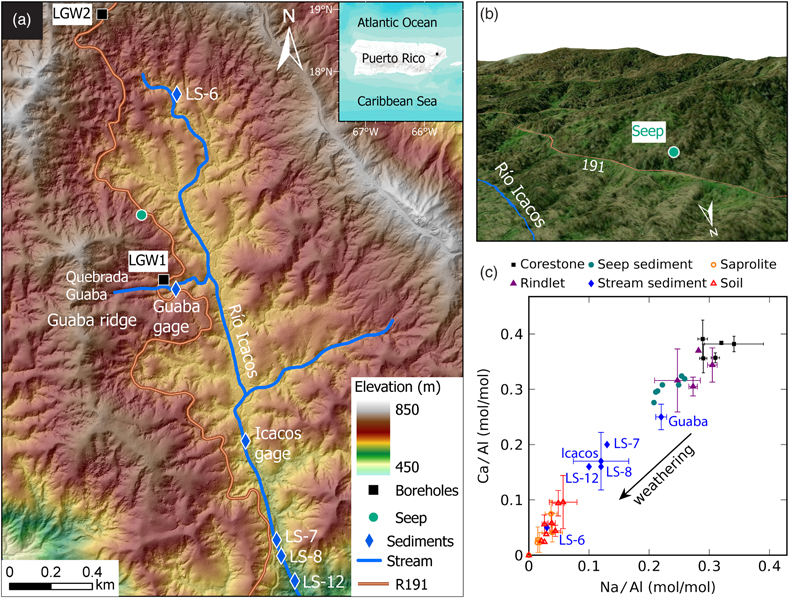
Figure 1 (a) Study locations at Río Icacos watershed in Puerto Rico. Colours indicate elevation, which are from USGS 3D Elevation Program through Open Topography. (b) Sampling location of seep sediments. Aerial imagery is from Esri (2017)
Esri (2017) “World Imagery” [imagery]. 1:6,700 scale. “World Imagery”. October 24, 2017. https://www.arcgis.com/home/item.html?id=10df2279f9684e4a9f6a7f08febac2a9. (September 16, 2021).
. (c) Na/Al and Ca/Al molar ratios of different solid end members (corestone, rindlet, seep sediment, stream sediment and saprolite/soil) determined through bulk analysis. Most Na and Ca are present in plagioclase in the bedrock, so as plagioclase weathers, the Na/Al and Ca/Al molar ratios decrease (Al is assumed to be not solubilised during plagioclase weathering).
Figure 2 (a) Hourly peak runoff and (b) maximum rainfall intensity during the sampling week versus weekly accumulated mass of seep sediments. P = p value.
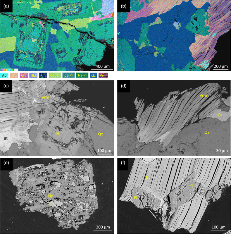
Figure 3 (a, b) Elemental maps and (c–f) backscattered electron images of the edge of rindlets (a–d) and seep sediments (e, f). The rindlet sample is from borehole LGW1 at 5.38–5.40 metres below land surface (LGW1 1-20) and the seep sediments were collected during August 9–16, 2016 (0.85–2.56 mm size fraction). Ap: apatite, Bt: biotite, Chl: chlorite, Hbl: hornblende, Kln: kaolinite, K-spar: K-feldspar, Pl: plagioclase, Qz: quartz, Vrm: vermiculite.

Figure 4 Si/Al and Ca/Al molar ratios determined by scanning electron microscopy energy dispersive X-ray spectroscopy (EDS) on individual plagioclase grains from different solid end members (corestone, rindlet and seep sediment). The orange circles represent sodium-rich (albite, Ab) and calcium-rich (anorthite, An) plagioclase and typical weathering products of plagioclase such as gibbsite (Gbs) and kaolinite (Kln). The dashed line represents solid solution mixing of Ab and An. Shaded zone shows one standard deviation of uncertainty in Ca/Al molar ratios assuming the relative error of EDS measurement is 5 %. Therefore, the points within the shaded zone are considered as unaltered plagioclase.